
For many years the city of Perrysburg has contemplated enhancing the existing dirt, gravel and grassy sections of the river walk path, partly on Water Street, from the Boat Club at Hood Park and Louisiana Avenue to the Maumee Bridge (roughly paralleling parts of the old, established cross-country ski trail). Now there is an immediate plan to upgrade the path, making it ADA (handicapped access) compliant at the same time, even though there is no immediate ready-access for a wheelchair to either end, other than by a driven vehicle. The new path routing is shown by the yellow line in the following two drawings by Tetra Tech, consulting engineers. These proposals were presented at City Hall last month for public comment:

Even before the public comment meeting, the city had cut trees and cleared a 15 ft. wide track through the west end of Orleans Park from the car park to the bridge, and then paved it with a 10 ft. wide asphalt strip. This new asphalt section lies between the two red “V” marks on the drawing above.

Note the locked, removable bollard which allows emergency vehicle access.
The new paved section did leave a small piece of the origin path intact, closer to the river. It’s always fun to find deer, cayote and other’s footprints in the old paths.

The new path does provide easy access from Orleans Park to Fort Meigs under the rebuilt Maumee bridge.

This is much appreciated by us cross-country skiers, skateboardes, cyclists and others as previously the skiers had to either remove their skis and walk across the road, or risk skiing the rough and questionable ice on the river under the bridge (the water there was shallow and so not too dangerous, but the current was troublesome when a ski did break through the ice).
Past the houses on West Front Street, between the extensions of Mulberry and Cherry Streets, (below the red line on the second proposal drawing below) there is currently a grassy path, happily used a few times a day by singles or couples, sometimes with a dog or two, without any problems. 

The posts delineate the approximate middle of the 60 ft. wide Water Street route owned by the city. The tilt of the once-vertical posts shows the instability of the clay slope on which the current grassy path lies as it passes the houses from Mulberry to Cherry Streets.
Water Street does not actually reach the river’s edge but runs between private lots: to the south, the Front Street houses are located on one lot, and on the north side of Water Street there is a corresponding grass covered lot running some distance into the river. The outlines of the lots are shown in blue on the second proposal drawing above.
The residence owners (full disclosure: I’m one of them) are concerned that the natural appeal of the existing natural grassy path will be lost if a heavy duty road, with possible safety fencing like that under the bridge, is built there.
The small island in the river (sometimes known as “Garden Island”) immediately north of this area frequently houses bald eagles, two of which are shown there in the photo below:

We all agree that they must not be disturbed.
A major concern is that expansion work, of previous years, on Water Street from the Boat Club at Hood Park (Louisiana Ave.) to the west end of Riverside Park, has proven to be disastrous. That section of dirt road is an invitation to questionable activities by private vehicular traffic. The following two true photos show a little of what happens there (undesirable litter and graffiti: you can click and zoom in on the photos if you need the sordid details).
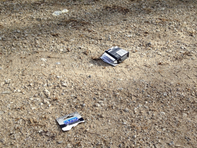

There is obviously not sufficient park servicing available to prevent, or clean up after, such behavior (the tree graffitti has been there for nearly 2 years). I see no reason whatsoever for private vehicles to have unlimited access to this piece of what should be normal city parkland. This section of Water Street from Hood Park to the west end of Riverside Park urgently needs to be cleaned up and converted to pedestrian use only, with private vehicles excluded (perhaps by the use of bollards as in the photo above at Orleans Park), except for agreed purposes.
The pedestrian traffic currently using the grassy path past the houses respect and enjoy the existing natural path and have not been seen leaving litter there.
I have yet to see a real demand for a paved path. After a well attended charrette meeting at City Hall last summer with about 40 people attending, nobody, other than concerned officials and two river front home owners, was sufficiently intereted to join a guided walk to actually view the area.
My hope is that if a more formal path must be made then grass paving blocks or some such unobtrusive, ADA compliant, semi-natural material could be used. Safety for independent wheel chair use could be added with an intermittent low (4 to 6 inch high) curb stone on the river side of the path. Such a curb must be at intervals to allow the residents to continue maintaining the grass on their own and the city’s lots, with their own mowing equipment, as they do at present.
Following is an image of the long term “Draft Master Plan” that was also distributed at the public meeting last month. This is a separate item with many very elaborate concepts, but should also be considered and discussed by all concerned before any work commences.
