A fresh hole appeared in the ground down the back near where I saw a beautiful 6 ft. long fox snake last year. Unfortunately there were no visible paw prints to help identify the hole’s occupant(s), so I put a CritterCam on it for a few days.
Animal curiosity soon prompted a picture:
First out, not surprisingly, was the Groundhog who keeps many of our plants trimmed down.
But a minute later out came another, smaller one.
The next day the hole was visited by what seems to be a Raccoon.
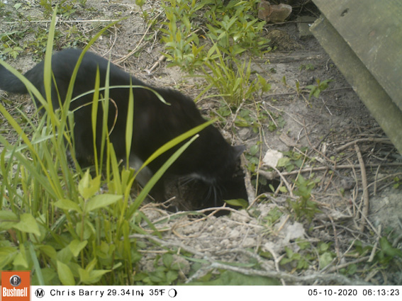
I’ve no idea what transpired down the hole but on the following day who should enter the hole but a black cat, with distinctive white paws (any neighbors recognize it?)
It did not stay long. A minute later it came out
and ran off.
Perhaps the cat is related to our rescue stray – Pinot – who is only allowed outside on the 3rd floor balcony.
That height does not stop her from looking longingly at the animal action below, but she has yet to find a way down.
I don’t know what transpired down in that hole in the garden but I might have to investigate it with my 3ft long fiberoptic view-scope? It has been good at finding the honey in the hollow Catalpa tree out by the front door, stored last year by swarming bees who have since disappeared.
Now that is honey that can only be accessed by cutting down the tree, or by simply using it to tempt the next passing swarm of bees to move in, stay and enjoy it. Here they are in action:
Finally, I have to find the hole(s) where the bats live. They are putting on a beautiful evening display these days, eating the bugs missed by the passing Warblers.
Here is a great free Cornell U. website to show you where you might see the various little yellow marked warblers on their migration from South America to NW Canada. It combines weather forecast data with bird spotting observations:
https://BirdCast.info/ Looks like Wednesday – Thursday should be good, when the cold spell passes.
“Sir, your garden is full of weeds!” – “My friend, the native birds and bees are all delighted to feed on our local Butterfly-weed, Ironweed, Jewelweed, Joe-pye-weed, Milkweed, Pokeweed, and other native foods familiar to their genetic history, which are happily growing in my garden”.
Initially I naively thought that native plants would look after themselves and one could a have an idyllic, self-maintaining, riverside forest glade needing nothing done to it but the making of initial plantings.
The plants native to this area do grow readily here but they were not the ones that were growing when I arrived. In Perrysburg, Ohio, we have traces of nearby ancient Black Swamp fertile humus over clay. A few miles distant are the Oak Openings sand ridges with a completely different flora and fauna. These two soil systems support unique and tempting plants but neither system immediately describes the clay of our site where the river has washed away most of the fertile top soil, and the construction of: houses, an old and abandoned ‘hydraulic canal’ and buried sewer pipes has removed the ‘remnant’ earth of ancient days from before the arrival of us current ‘invaders’. Such ‘remnant’ soil, if it were only available, would be ideal for the re-establishment of the original flora and fauna of the old savannah.
I was surprised to see that the widespread alien English Ivy and Japanese Honeysuckle offered no nutrition to our native Ohio caterpillars, and yet the many foreign English sparrows and Japanese beetles here happily fed on the Ohio native plants. I later read that butterfly larvae are picky eaters and look for familiar food, while plants are slow to evolve the bitter tasting protective juices needed to resist many beetle invaders.
I manually pulled out the aliens – the Asian Trees of Heaven (Ailanthus) were the biggest challenge. Sadly their good looking companion Ailanthus bugs went with them:but the rotting Ailanthus stumps are producing some interesting mushrooms.
So, after vainly trying many different native species, I started listening to what the plants were telling me and began to grow: River Oat grass, Meadow Sunflower, Jacobs Ladder, Ferns, Jewelweed, Nine Bark, Pussy Willow and other natives,with good success. But not before being seduced by the Ohio spring ephemerals:Bloodroot (above), Spring-beauty, May-apple, Trilliums, Trout-lily, Dutchman’s breeches, and Jack-in-the-Pulpit, Wild-ginger, all of which can now make the exciting announcement that winter has finally ended in our back garden.
These early spring successes did not tell me they needed protection against the later seasonal invasion of the aliens: Myrtle, Indian Strawberry,Ground-ivy, Garlic-mustard, escaped Yellow Archangel, etc., etc..
We are still seeking the perfect native plants which will come later in the year and protect the spring ephemeral sites without overwhelming them. Poke-weed, and Goldenrod:do grow well but seem to be too aggressive. Wild Senna, Snakeroot and Wingstem also flourish in the hard clay but even they might not leave enough room for our precious ephemerals?
To my great delight I found the native plants were starting to support a zoo of native animals: Monarch butterflies and a wide variety of weird and wonderful caterpillars:
Fox Snakes, Mink:
and many birds including migrating Warblers (below in a Redbud tree),
White Pelicans, Sandhill cranes, and even an uncommon pair of Red Headed Woodpeckers
The smaller ‘bugs’ have been most fascinating when one stops to peer at them closely:
These Striped leaf-hoppers:love the Jewel-weed plant (it has a water-shedding leaf: rain drops bead up on it and roll off like water from a duck’s back):
Hiding under its leafy canopy is a beautiful flower:
Realizing that this location is one small step on two unofficial wildlife corridors: one running NE to SW, parallel to the Maumee River, as taken by the Monarch butterflies travelling between Quebec, Canada and Mexico, and the other taken by Warblers migrating between the Caribbean and NW Canada, I am now trying to entice them all to stop over for dinner on edible patches of native plants and bugs, hopefully visible from the air. The latest effort has been a transplant of 40 Milkweeds, complete with their long horizontal roots, down to the river bank, from out front by the street where air turbulence from traffic tumbled the poor Monarch butterflies.
So I have learnt to plant natives, extirpate aliens, and never use any poison insecticides, herbicides or fungicides. The results continue to amaze. One only has to learn to observe properly.
Meanwhile I hope that this small effort, by deed and example, can help a little to stem the current loss of so many species in our rapidly changing world. Are you old enough to remember when a car windshield was heavily smeared with dead bugs after a short summer evening drive? That does not happen now. Why have those bugs gone? And what can we do to save the handful that are left?
December 2017 and the first half of January this year have been very cold in Perrysburg, Ohio.
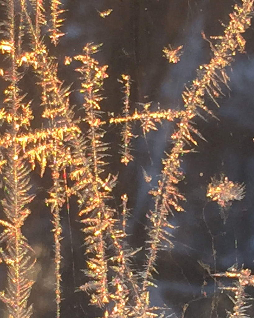
The frost patterns on my old, non-sealed, manual storm-glazed windows were fascinating as always: Are these frost lines built molecule by molecule showing us precise angles that exist at that very small level? How else can such a thin line be grown so straight? And then sometimes they curve, to follow perhaps the fine line of a window cleaner’s scratch? Some other lines must be following isotherm lines showing heat flow currents?
Brendan pointed out similar patterns in BBC videos, findable on You-Tube, where people are freezing soap bubbles and watching the frost fronds grow – in time lapse movies? One very cold and windy night I thought of going outside to make one, but never got there. Now it is too warm. Anyone ever tried it?
The cold made very beautiful, fine snow for 20 days of excellent cross-country skiing even though it lacked the base of heavy wet snow which usually falls first. I only skied 18 of them because for two days it was below 10 F (-12 C) which is uncomfortable, unless the sun is shining and there is no wind.
The fine snow was almost too fast, and then got even faster as we skied it. Peter D in Calgary told me how to iron in the blue ‘Glider’ wax I’d bought years ago in a Finland summer visit. A dedicated domestic iron now lives in the basement for the new task. So speed is no longer an issue. But without a frozen groove set in the snow it was hard to control the direction of the skis.
A few day’s work had cleared the fallen trees and branches in the wilderness areas. Fortunately two new skiers to the trail, Michael B and Bill T helped set the track. So conditions were superb. Now, Jan. 22, it is warm and the bees are flying! The fun has ended but some of us hope for more in a few days time.
My lovely iPhone trail mapping ap. from Sierra Club stopped working when the latest ‘upgrade’ to the phone operating system was installed. Fortunately there are many other similar aps. out there (in cyberspace). My latest one is “Topo Maps+” which, for a few $$, supplies great map detail. But it will not email the resulting map (for copyright reasons?). A “screen dump” used to give me a Photoshopable copy but the new iPhone op system now seems to block that too. Finally, mailing the phone screen-dumped image to my laptop and then taking a “Print Screen” image of that at last gave me a file I could edit and annotate in Photoshop!
So here is this season’s Cross-Country Ski Map. From the Riverside Park Cannons to Fort Meigs and back is 3.74 miles, with an elevation change of reportedly about 200 ft.
The blue arrow indicates the ski trail starting at the USS Constitution (replica) Cannons at Riverside Park. Follow the blue trail through the woods, into Orleans Park along the river, under the bridge, alongside Crooked Creek, around Fort Meigs (Clockwise for best speed), and back. The more people who ski it the better it gets. Please come and join the fun!
Pay close attention to the section at the service road the west side of Fort Meigs. Note the many contour lines close together! Even cross country skis can get to 20 mph on this one. Stick to the right hand side of the service road for good grass conditions under the snow. Two days ago, on thin snow, I foolishly stayed to the center of the road but contacted the gravel surface. Even at slow speed, gravel quickly stops skis while momentum keeps the skier’s body moving forward, for a little time at least!
More unexpected adventures were had in the Orleans Park section. Four days ago the ice break up created a dam – the Maumee river rose, flooded my ski trail, froze, and then subsided, leaving a thick flat ice slab poorly supported by shrub stems and such. Under the ice was air, and then water below that. But the ice was unsupported by water and so had no strength. It all resulted in one very cold wet skier.
Getting to one’s feet again is surprisingly awkward when immersed in cold wet, slippery ice, with nothing good to hold onto and with feet fastened to underwater skis! Any tips anyone?
Back home about a thousand Canada geese have gathered from a large surrounding area at the only open water hole, and are leaving a large amount of phosphorous containing material to feed the summer river and lake algae.
The only other birds, apart from the local waddling ducks, are about 20 very elegant Mergansers which are far too wild to be photographed up close.
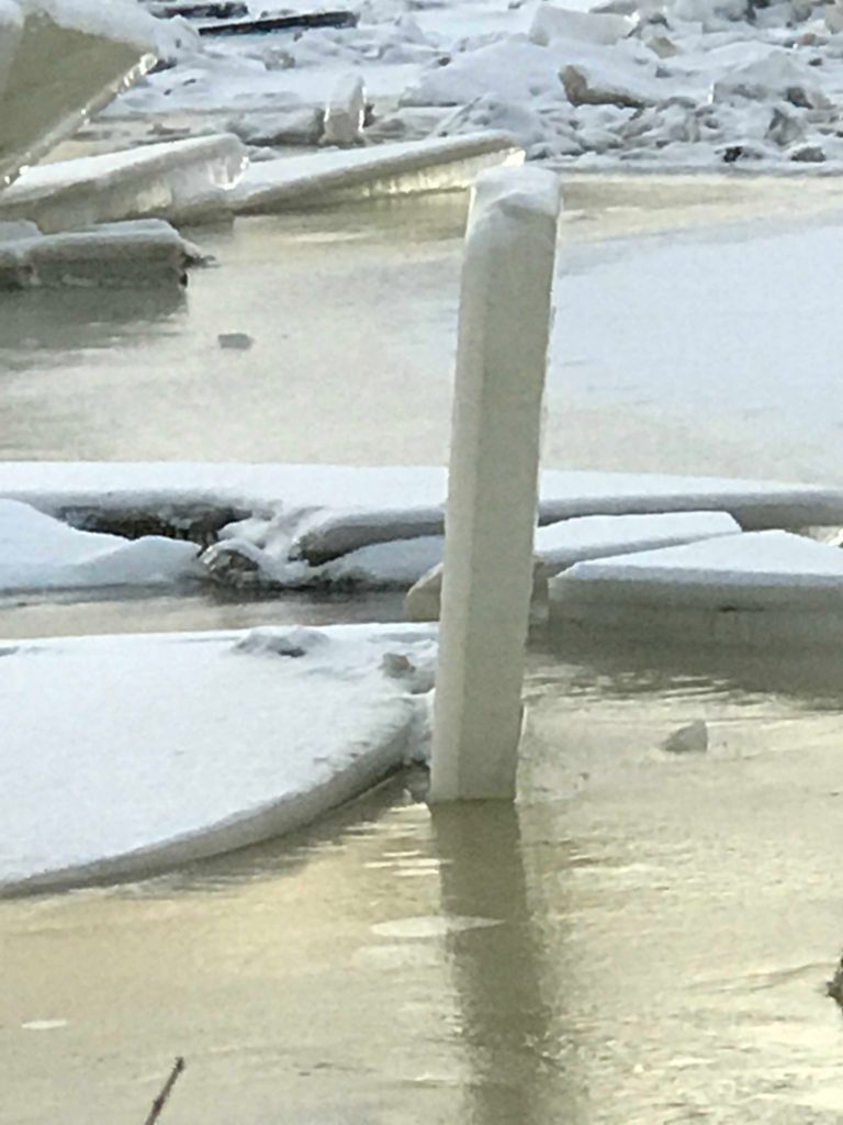
A Perspective Puzzle:
The top 4 or 5 ft. of this vertical slab of ice, about 50 ft. away, viewed edge-on in the photo above with the camera pointing due North, and with its lower edge firmly resting about 6 ft. underwater in the Maumee mud, has a strange perspective property. When seen from about 15 deg. to the right side (camera pointing NNW) it seems to tilt slightly to the left. See photo below:
But when viewed from about 90 deg. around to the left side (camera pointing due East), see below, where its true (parallelogram?) shape can perhaps be better imagined, it seems to take on a huge tilt to the right. I assure you, it is still vertical but to me it does look like a good sloping launch ramp for some adventurous jumper.
Maurice C suggested making a video while I walk past it. You can see that in the link below. The perspective illusion still there.
Of course there is a U-Tube example of a similar effect which Maurice showed me. You can find it by Googling “Amazing Rooftop Illusion “ or at https://www.youtube.com/watch?v=ui6j-j1jXcE
Winters on Toronto Island
The best story this month was the New York Times article by Catherine Porter on the winter activities of the Toronto Islanders: shinny; ice boating; even polar bear dipping. But there was no mention of cross-country skiing: That was where I first learned the sport 50 years ago. David Hendry found you could buy very old wide wooden skis for about $2 at the then politically incorrectly called (but perhaps accurately because those skis had the old and dangerous ‘rat trap’ bindings) “Crippled Civilians” store on Jarvis Street. It is now the “Goodwill store. We planed the sides down to about 2/3 of their original width and got great cross-country use out of them.
The NYT article should be available at:
Here is a poor photo of it in case the above link doesn’t work:


 Looks like Wednesday – Thursday should be good, when the cold spell passes.
 but the rotting Ailanthus stumps are producing some interesting mushrooms.
  Bloodroot (above), Spring-beauty, May-apple, Trilliums, Trout-lily, Dutchman’s breeches, and Jack-in-the-Pulpit, Wild-ginger, all of which can now make the exciting announcement that winter has finally ended in our back garden.
 do grow well but seem to be too aggressive. Wild Senna, Snakeroot and Wingstem also flourish in the hard clay but even they might not leave enough room for our precious ephemerals?


 love the Jewel-weed plant (it has a water-shedding leaf: rain drops bead up on it and roll off like water from a duck’s back):